Portugal
Lisbon
Portugal’s capital on the Tagus: Alfama’s hills, Baixa’s squares and a renewed waterfront
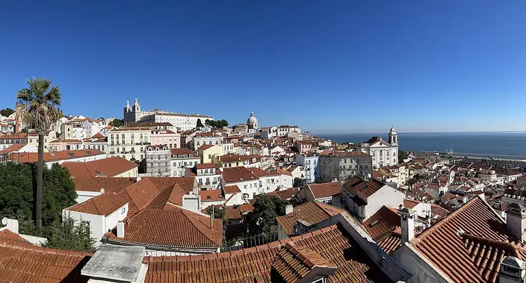
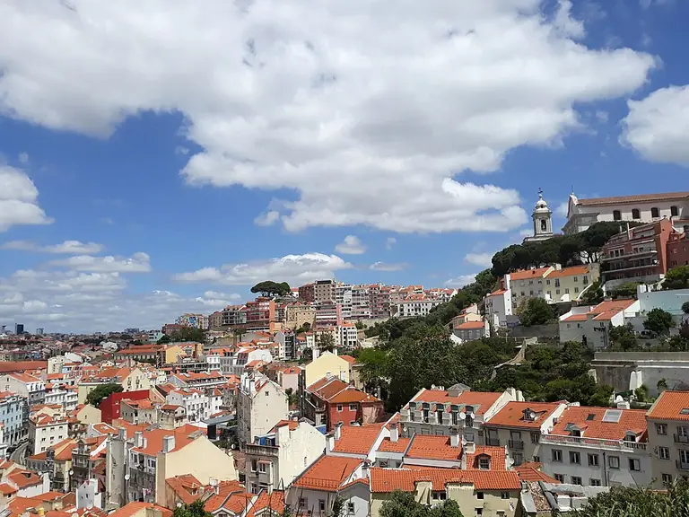
Lisbon brings together Alfama’s cobbled slopes, Baixa’s ordered streets and an extensive riverfront stretching from Belém to Parque das Nações. Fado, architecture, gardens and everyday walks between squares offer different ways to discover the city. When choosing somewhere to live, look closely at the actual street: the climb from a stop, the building entrance and the route to regular activities shape daily life more than a well-known neighbourhood name.
- Country
- Portugal
- City role
- Capital of Portugal
- Municipal structure
- 24 freguesias, or civil parishes
- River
- The Tagus, called Tejo in Portuguese
- Modern waterfront
- Parque das Nações: the legacy of Expo 1998
Explore the destination
The municipality and the wider metropolitan area
Lisbon municipality is divided into 24 freguesias, while the Área Metropolitana de Lisboa comprises 18 municipalities. Cascais, Sintra and Almada belong to that wider area but are not districts of Lisbon municipality. Historic names such as Alfama, Baixa and Chiado do not replace an administrative address either. Start a housing comparison with the municipality, parish and street, then connect that address to work, study and the journeys you make regularly.
Alfama: a city of lanes and fado
Alfama is formed by cobbled lanes, steps and slopes. At Santa Luzia, a garden, pond and decorative tiles complement the Tagus panorama; look at the viewpoint itself as well as the view. The Fado Museum explores the urban song through performers, documents and a multimedia exhibition. Pick a few separate stops for a walk and allow time for the climbs. A terrace view helps explain the terrain, while walking your actual route is a better test of everyday convenience.
Baixa and Chiado: two ways to read the centre
Baixa’s rectangular street grid grew from reconstruction after the earthquake of 1755. Rua Augusta leads through the arch to Praça do Comércio, where the river becomes part of the square’s setting. Higher up, Chiado has shops, studios and cafés, with theatre and book culture adding a character of its own. Compare the transition from lower streets to upper ones as well as the façades: addresses that seem similar on a map may involve different walks and different routines on the way home.
Belém: monastery, industrial history and modern architecture
Jerónimos Monastery, commissioned by Manuel I, introduces Belém’s monumental architecture; the church and cloister deserve separate attention when planning a visit. MAAT represents another chapter: the brick former Central Tejo power station stands beside the low contemporary gallery building opened in 2016. A route here can combine history, art and technology. Choose a theme and specific buildings in advance, leaving separate time for the riverfront and the connections between cultural venues.
Parque das Nações and gardens on a different scale
The eastern riverfront was transformed for Expo 1998. The Oceanarium, Pavilhão de Portugal, Pavilhão do Conhecimento, gardens and public artworks preserve Parque das Nações’ connection with the exhibition. Explore the public spaces alongside individual cultural buildings. Jardim da Estrela offers another experience: a garden opened in 1852 with a distinctive green bandstand. Choosing between a riverfront walk and garden paths is more useful when linked to an activity you would like to repeat on an ordinary day.
Transport as several connected systems
The metro uses colour-named lines: Aeroporto and Oriente are on the Red line, while Baixa-Chiado connects the Blue and Green lines. CARRIS buses and trams complement the metro, and CP suburban trains serve the Sintra, Azambuja, Cascais and Sado lines. For an individual address, check the station exit, climb to the building and return journey as well as the interchange. Current diagrams, disruption notices and lift status matter more than an old route description; a planned network extension should not be treated as an available journey.
Orientation coordinates: GeoNames · CC BY 4.0. Coordinates reproduced unchanged; this is a city reference point, not a property address.
Choosing where to live and getting to know Lisbon
Connect your impressions of the city with daily routines: the climb home, a journey across the river, a garden walk or an evening at a cultural venue. These articles help move from a neighbourhood name to checking an actual address.
The street matters more than the area label
Administrative location, terrain and the approach to a building provide three different layers of useful information in Lisbon.
Read more
Municipality, parish and neighbourhood
First establish whether an address is in Lisbon municipality or another municipality in the metropolitan area. Then identify its freguesia and exact street. The name Alfama suggests a historic setting but does not provide a complete administrative address. Make a short list of regular destinations and test the route to each one. This turns an appealing neighbourhood description into a clearer picture of the working week.
Slopes, steps and the surface underfoot
In Alfama, climbs and steps are part of the urban fabric. Calçada portuguesa, patterned paving made from hand-laid stone cubes, appears elsewhere in Lisbon too; look for its designs on Avenida da Liberdade and in Chiado. When viewing a home, walk from the stop to the entrance with your own needs in mind. Notice steps, passage width, lighting and paving condition, and check separately whether the building has a lift.
Baixa’s squares and Chiado’s upper streets
Rossio is the familiar name for Praça de D. Pedro IV, one of Baixa’s squares. Start with the square, explore the ordered street grid and then climb towards Chiado’s shops and cafés. If considering a home here, return to the actual street at the time you would normally get home. Find where everyday shopping would happen and listen to the surroundings by the windows: an impression of a public square does not describe every residential entrance.
Check the complete door-to-door journey
Metro, tram and suburban rail serve different purposes; an address’s convenience becomes clearer at interchanges and on the final walk.
Read more
Metro: the right line and the right exit
The Red line includes Aeroporto and Oriente, while Baixa-Chiado is an interchange between the Blue and Green lines. Start with the direction you need, then identify the specific exit and remaining walk. If step-free travel matters, check the relevant lifts, including those at an interchange. Compare journeys at the times you actually travel and allow for walking connections; a station name in a property description does not establish the convenience of the whole trip.
The tram map and service changes
Tram 28E helps explain a historic urban corridor through Graça, Portas do Sol, Santa Luzia and Sé. The 15E route diagram includes stops for Belém and Jerónimos. Before travelling, however, check the current route, destination and CARRIS notices: services can be temporarily diverted or shortened. For regular trips home, identify an alternative and compare the approach to the stop. Do not make a transport service the sole condition for a successful day without checking it for your date.
CP and journeys beyond the municipality
The Cascais line includes Cais do Sodré and Belém; the other CP urban rail lines are Sintra, Azambuja and Sado. The name Lisbon Urban Trains describes a wider network, so your final address may be outside Lisbon municipality. Check the station you need, the stops of the particular train, possible works and the last leg after arrival. When comparing homes, assess the return journey as well as a convenient morning departure.
Choose a cultural theme of your own
Song, monastic architecture and the history of electricity offer three independent routes that do not have to fit into a single day.
Read more
The Fado Museum: hearing urban history
Opened in 1998, the Fado Museum holds instruments, scores, photographs and other evidence of the genre’s life. Its permanent exhibition traces the story from nineteenth-century Lisbon and uses multimedia interpretation. It offers a way to get to know the music before a separate evening of live performance. Allow time for attentive listening, and check concert programmes and visiting arrangements separately; a museum visit and an evening performance reveal the tradition in different ways.
Jerónimos: understanding a monument’s spaces
Jerónimos is associated with Manuel I’s commission and was inscribed on the World Heritage List in 1983. When planning, distinguish the church from the cloister: they are separate spaces within the complex, and access arrangements need checking. Look closely at the stonework, proportions and transitions between open and enclosed areas. If architecture is central to your exploration, give this visit time of its own rather than treating it as a short stop between several museums.
MAAT: energy, art and the river landscape
At MAAT, compare Central Tejo’s brick industrial architecture with the AL_A gallery opened in 2016. The former power station houses the permanent Electricity Factory exhibition, while temporary shows introduce other subjects. Decide whether technology, contemporary art or the building itself interests you most and check the available programme. Walking the outside spaces and seeing an exhibition require different amounts of time; plan them as separate parts of the day.
Try out your favourite everyday walk
A garden, river steps and a viewpoint suggest different routines. Assess the way there as carefully as the attractive destination.
Read more
Jardim da Estrela for a repeatable route
Jardim da Estrela, also called Jardim Guerra Junqueiro, opened in 1852; one entrance faces the Estrela Basilica. Its green wrought-iron bandstand provides a recognisable meeting point. If a regular walk matters to you, try a comfortable loop, find places to pause and assess the route from a home you are considering. Check the actual entrance rather than just the garden’s name on a map, especially if steps, a pushchair or a gentle pace matter.
Ribeira das Naus: by the water without swimming
The former Ribeira das Naus shipyard has become a green space with broad steps towards the Tagus. This riverfront connects Cais das Colunas with Cais do Sodré; bathing is prohibited. It is a place for walking and taking a break beside the water. For your own route, consider exposure to sun and wind, crossings and where you would rejoin transport. Do not translate a river panorama into a claim about an individual apartment’s accessibility without checking the whole walk.
Santa Luzia and Portas do Sol: look at the details
Santa Luzia offers tiles, a garden and a pond as well as rooftops and the Tagus. At Portas do Sol, a different landmark is the statue of Saint Vincent with a boat and two ravens, symbols of the city. Compare the viewpoints as separate spaces and choose a climb that suits you. If scenic walks would be part of your routine, try the return route and plan pauses too; a beautiful panorama does not remove the challenges of the terrain.
Properties in the city
- Infinity
- Terraços do Monte
- Tomás Ribeiro 79
- Castilho 203
- A’Tower
- Prata Riverside Village
- Jardim da Glória
- Trigo
- Santa Helena
- Matinha
Photo credits
1. Dudva · Lisbon rooftops and panorama · CC BY-SA 4.0. Resized, WebP format.
2. acediscovery · Lisbon looking towards Graça · CC BY 4.0. Resized, WebP format.