United States
Miami
A skyline, museums and leafy neighbourhoods beside Biscayne Bay
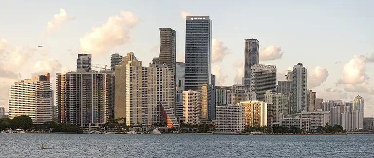

Miami, Florida, unfolds through the high-rise streets of Downtown and Brickell, leafy Coconut Grove, Little Havana’s Cuban-American culture and Wynwood’s art. Biscayne Bay, the Miami River and distinct transport systems help explain its geography. When choosing where to live, connect a neighbourhood’s character with the actual address and your everyday journeys.
- Country and state
- United States, Florida
- Administrative setting
- City of Miami in Miami-Dade County
- City incorporation
- July 28, 1896
- Water landmarks
- Biscayne Bay and the Miami River
- Local transport
- Metrorail, Metromover and bus routes
Explore the destination
Miami, Miami Beach and the county
Miami is a separate city within Miami-Dade County. Miami Beach and Coral Gables are independent municipalities too, so the wider name Greater Miami does not establish an address’s precise location. South Beach and its celebrated Art Deco architecture are in Miami Beach. To explore the urban setting, first establish the municipality, then the neighbourhood and street: this sequence helps you compare commuting, everyday walks and trips to the ocean meaningfully.
The river and the high-rise centre
The Miami River helps distinguish Downtown from Brickell: their high-rise skylines stand on different sides of its mouth beside Biscayne Bay. In the centre, urban activity combines with walks in Bayfront Park, with its public art and open waterfront spaces. When exploring a residential street, look beyond the skyline: walk from the building entrance to the crossing, stop and everyday shop you would use. Set a specific entrance as your destination for a waterfront walk.
Several architectural languages
Miami’s architecture includes Mediterranean Revival, Art Deco, Craftsman bungalows and Bahamian wooden houses. At PAMM, a broad canopy, raised platform and veranda show a contemporary response to climate and parkland; at Vizcaya, the central courtyard and bay-facing façade reveal the organisation of a historic villa. Exploring South Beach’s tropical Art Deco means a separate trip to Miami Beach. Compare scale, details and relationships with the street without transferring impressions of a museum façade to the qualities of a home.
Neighbourhoods and cultural memory
Coconut Grove combines shaded streets and waterfront parks with the history of Village West’s Bahamian and African American communities. Calle Ocho is an important axis of Cuban-American culture in Little Havana, while Wynwood introduces murals and galleries. These places invite different activities: walking residential streets, exploring local history or looking closely at art. Choose a theme and a few destinations, leaving time for the neighbourhood itself; the name of a popular area does not describe every surrounding street.
Art, science and a historic estate
Pérez Art Museum Miami explores twentieth- and twenty-first-century art, including Latin America, the Caribbean and the African diaspora. In Maurice A. Ferré Park, Frost Science brings together an aquarium, planetarium and exhibition spaces. Vizcaya in Coconut Grove offers a different scale of experience: James Deering’s house and a garden landscape beside the bay. Choose one main theme for a fuller visit and check the programme, entrances and admission arrangements; a park walk and a museum exhibition need different planning.
Transport with clear connections
Metrorail serves a wider urban corridor, while Metromover is a separate elevated system in Downtown, Omni and Brickell. MIA Mover links the airport terminal with the transport interchange and rental-car area; choose the onward train or bus separately. Miami Beach has bus connections, including Airport Express 150 from the airport station. Check the journey for your travel date: transfers, lift status and the evening return matter more than a station name in an address description.
Orientation coordinates: GeoNames · CC BY 4.0. Coordinates reproduced unchanged; this is a city reference point, not a property address.
Choosing where to live and getting to know Miami
Build your own picture of the city through individual streets, transport connections and favourite activities. These articles help move from a neighbourhood name to checking an actual address, adding everyday experience to impressions of the skyline.
Start with the city’s geography
The municipality, neighbourhood character and everyday street provide three different layers of information.
Read more
Downtown, Brickell and separate Miami Beach
Downtown and Brickell meet around the Miami River and Biscayne Bay, but a journey needs a specific riverbank and building entrance. If South Beach’s tropical Art Deco streets appeal, you are considering the separate municipality of Miami Beach. Write down your main destinations: work, a regular walk and everyday shopping. Then check the trip to each one from the home you are considering. This adds a clear picture of an ordinary day, including the evening return, to an architectural impression.
Coconut Grove: greenery and historic streets
In Coconut Grove, notice both the waterfront spaces and historic Village West. Bahamian heritage appears in the area’s history and wooden buildings, including the Charles Avenue area. Walk the street you are considering, looking at pavements, crossings and shade on the way to your stop. Check the building approach, window orientation and everyday amenities separately. A walk along a public street helps you understand the setting; access inside a historic or residential building needs its own check.
Little Havana and Wynwood: different reasons to explore
Calle Ocho is SW Eighth Street in Little Havana, where cafés, murals and Domino Park introduce Cuban-American culture. In Wynwood, you can explore street art and galleries; the Wynwood Walls museum has its own entrance and visiting arrangements. Choose a few places of interest and check their programmes separately. When assessing a home, return to its particular street at the times relevant to your routine: impressions from a cultural walk are worth complementing with observations of everyday life.
Break the journey into individual stages
Similar transport names cover different networks, terminal stations and transfer arrangements.
Read more
From the airport: MIA Mover, then your onward line
MIA Mover takes you from the airport terminal to the Rental Car Center and interchange area for onward bus and rail journeys. The Metrorail airport station is served by the Orange Line. At weekends, its airport section operates as a shuttle to Earlington Heights, requiring a transfer to continue on Metrorail. Before leaving, check the service pattern for your day and lift status. Include the walk through the terminal, the connection between systems and the final leg to your address in your timing.
Metromover for central neighbourhoods
Metromover runs above the streets of Downtown, Omni and Brickell on three loops. You can change between it and Metrorail at Government Center and Brickell. Before boarding, confirm the loop and car destination; for your return, check current hours and maintenance notices. If considering a home in the centre, try the route from the platform to the building entrance and back. Assess crossings, lifts and waiting areas in the conditions in which you would normally travel.
Tri-Rail and a journey to Miami Beach
In the Tri-Rail timetable, Miami Airport and MiamiCentral are different stations; trains also serve Fort Lauderdale and West Palm Beach. MiamiCentral journeys normally involve a connecting Tri-Rail train at Metrorail Transfer, with particular express exceptions. Check your individual service. For Miami Beach, explore a bus route such as Airport Express 150 from the airport station via Julia Tuttle Causeway. Compare the complete journey and return departure: regional rail travel and a trip to the beach serve different purposes.
See the city through its museums
Contemporary art, science exhibitions and a historic estate offer different ways to discover Miami.
Read more
PAMM: art and architecture in one visit
PAMM’s collection gives particular attention to Latin America, the Caribbean, the African diaspora and the US Latinx experience. The Herzog & de Meuron building is notable for its broad canopy and veranda; Patrick Blanc created the hanging gardens with the architects. First choose an exhibition you want to see, then leave time for the spaces around the galleries. Notice how light and scale change as you move towards the outside. Check the current displays and accessible areas for your visit date.
Frost Science: choose your main interest
Frost Science combines an aquarium, planetarium and exhibition buildings in Maurice A. Ferré Park. Decide what interests you most: aquatic ecosystems, space or interactive science exhibits. Check show times and access to specific areas in advance so they do not compete with another appointment in the city. Some areas, including rooftop terraces and the Aquarium’s Vista level, are exposed to the weather. Plan how to alternate indoor and outdoor spaces, and check the approach from Museum Park station if arriving by Metromover.
Vizcaya: a house, garden rooms and the bay
James Deering first spent a winter in Vizcaya’s Main House in 1916. Its central courtyard organises the interior, while the monumental east façade faces the bay. In the gardens, European influences unfold through separate spaces, geometric parterres and sculptural details. Choose what to examine most closely: the organisation of the house or the sequence of garden rooms. Allow time to move between them and check current access. Plan the museum as a visit in its own right rather than an incidental stop between home viewings.
Try out your everyday walk
A waterfront panorama becomes more useful when choosing an address once you understand the entrance, approach and return route.
Read more
Bayfront Park: lawns and art beside the water
Bayfront Park combines open lawns, paths beside the bay and public art. Isamu Noguchi’s works here include Slide Mantra and the Challenger Memorial; the park is also associated with his 1980s redesign. For a regular walk, identify a comfortable section, somewhere to pause and an exit towards your next destination. Check the event programme and actual access for your day. If comparing homes, walk the complete route from the building, noticing crossings and the return journey as well as the view.
Maurice A. Ferré Park: a walk and a museum day
Maurice A. Ferré Park, formerly known as Museum Park, offers a bayfront walk and a promenade from Biscayne Boulevard towards the water. Distinguish its name from the Metromover station called Museum Park. Choose a specific plan: a short outing by the bay or a walk added to a museum visit. Before travelling, find your entrance and check which spaces are accessible. When exploring the area, notice places to rest, sun-exposed stretches and street crossings on your own route.
Regatta Park and The Barnacle: two views of Coconut Grove
At Dinner Key Marina, Regatta Park introduces the sailing landscape through paths, picnic tables and bay views. The Barnacle has a different theme: an 1891 historic house and a surviving piece of the local hammock woodland landscape. Set separate destinations and check entrances for these places, particularly if you want to enter the house museum. Choose a suitable walk length and plan the return. Being near water on an overview map does not by itself establish the route from a particular residential building.
Properties in the city
- Baccarat Residences Miami
- Casa Bella Residences by B&B Italia
- The St. Regis Residences, Miami
- Missoni Baia
- Una Residences
- LILLI
- Villa Miami
- Quantum on the Bay
- 900 Biscayne
- Park Grove
- Grove at Grand Bay
- Viceroy Brickell
Photo credits
1. Wilfredor · Miami waterfront and high-rise skyline · CC0. Resized, WebP format.
2. B137 · Downtown Miami and Brickell viewed from the west · CC0. Resized, WebP format.